|
| at: |
Talladega National Forest |
Data from USFS GIS
 show on map
 animate
Trail users:


Elevation Profile
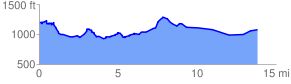
 14.266145 mi
 1138.82 ft
 1297.19 ft
 -158.37 ft
 1.72 %
GPX Downloads: Track Route
![]()
|
| at: |
Talladega National Forest |
show on map
animate
14.266145 mi
1138.82 ft
1297.19 ft
-158.37 ft
1.72 %