|
| at: |
Talladega National Forest |
Data from USFS GIS
 show on map
 animate
Trail users:


Elevation Profile
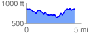
 4.429772 mi
 629.30 ft
 627.77 ft
 1.53 ft
 2.69 %
GPX Downloads: Track Route
![]()
|
| at: |
Talladega National Forest |
show on map
animate
4.429772 mi
629.30 ft
627.77 ft
1.53 ft
2.69 %