|
| at: |
Talladega National Forest |
Data from USFS GIS
 show on map
 animate
Trail users:


Elevation Profile
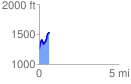
 0.630852 mi
 333.12 ft
 71.04 ft
 262.08 ft
 10.00 %
GPX Downloads: Track Route
![]()
|
| at: |
Talladega National Forest |
show on map
animate
0.630852 mi
333.12 ft
71.04 ft
262.08 ft
10.00 %