|
| at: |
Talladega National Forest |
Data from USFS GIS
 show on map
 animate
Trail users:


Elevation Profile
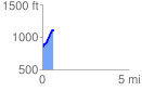
 0.637755 mi
 277.15 ft
 16.97 ft
 260.17 ft
 8.23 %
GPX Downloads: Track Route
![]()
|
| at: |
Talladega National Forest |
show on map
animate
0.637755 mi
277.15 ft
16.97 ft
260.17 ft
8.23 %