|
| at: |
Talladega National Forest |
Data from USFS GIS
 show on map
 animate
Trail users:


Elevation Profile
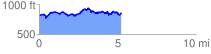
 5.292985 mi
 639.62 ft
 602.48 ft
 37.14 ft
 2.29 %
GPX Downloads: Track Route
![]()
|
| at: |
Talladega National Forest |
show on map
animate
5.292985 mi
639.62 ft
602.48 ft
37.14 ft
2.29 %