|
| at: |
Talladega National Forest |
Data from USFS GIS
 show on map
 animate
Trail users:


Elevation Profile
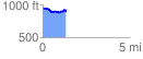
 1.348329 mi
 86.25 ft
 153.15 ft
 -66.90 ft
 2.15 %
GPX Downloads: Track Route
![]()
|
| at: |
Talladega National Forest |
show on map
animate
1.348329 mi
86.25 ft
153.15 ft
-66.90 ft
2.15 %