|
| at: |
Talladega National Forest |
Data from USFS GIS
 show on map
 animate
Trail users:


Elevation Profile
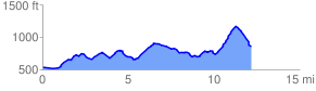
 12.390317 mi
 1601.08 ft
 1333.10 ft
 267.98 ft
 2.45 %
GPX Downloads: Track Route
![]()
|
| at: |
Talladega National Forest |
show on map
animate
12.390317 mi
1601.08 ft
1333.10 ft
267.98 ft
2.45 %