|
| at: |
Talladega National Forest |
Data from USFS GIS
 show on map
 animate
Trail users:


Elevation Profile
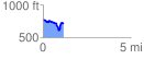
 1.172947 mi
 160.14 ft
 211.73 ft
 -51.59 ft
 3.42 %
GPX Downloads: Track Route
![]()
|
| at: |
Talladega National Forest |
show on map
animate
1.172947 mi
160.14 ft
211.73 ft
-51.59 ft
3.42 %