|
| at: |
Talladega National Forest |
Data from USFS GIS
 show on map
 animate
Trail users:


Elevation Profile
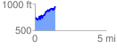
 1.447251 mi
 485.26 ft
 258.71 ft
 226.55 ft
 6.35 %
GPX Downloads: Track Route
![]()
|
| at: |
Talladega National Forest |
show on map
animate
1.447251 mi
485.26 ft
258.71 ft
226.55 ft
6.35 %