|
| at: |
Talladega National Forest |
Data from USFS GIS
 show on map
 animate
Trail users:


Elevation Profile
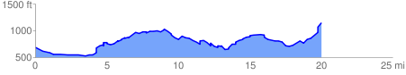
 20.307005 mi
 2510.04 ft
 2025.91 ft
 484.13 ft
 2.34 %
GPX Downloads: Track Route
![]()
|
| at: |
Talladega National Forest |
show on map
animate
20.307005 mi
2510.04 ft
2025.91 ft
484.13 ft
2.34 %