|
| at: |
Talladega National Forest |
Data from USFS GIS
 show on map
 animate
Trail users:


Elevation Profile
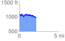
 2.106868 mi
 355.20 ft
 459.46 ft
 -104.26 ft
 4.13 %
GPX Downloads: Track Route
![]()
|
| at: |
Talladega National Forest |
show on map
animate
2.106868 mi
355.20 ft
459.46 ft
-104.26 ft
4.13 %