|
| at: |
Talladega National Forest |
Data from USFS GIS
 show on map
 animate
Trail users:


Elevation Profile
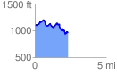
 2.332514 mi
 367.42 ft
 503.92 ft
 -136.49 ft
 4.09 %
GPX Downloads: Track Route
![]()
|
| at: |
Talladega National Forest |
show on map
animate
2.332514 mi
367.42 ft
503.92 ft
-136.49 ft
4.09 %