|
| at: |
Blue Ridge WMA |
Data from David Muse
 show on map
 animate
USFS GIS data shows this road as FS58B
Trail users:


Elevation Profile
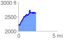
 2.295620 mi
 893.75 ft
 457.73 ft
 436.02 ft
 7.37 %
GPX Downloads: Track Route
![]()
|
| at: |
Blue Ridge WMA |
show on map
animate
USFS GIS data shows this road as FS58B
Trail users:
2.295620 mi
893.75 ft
457.73 ft
436.02 ft
7.37 %