|
| at: |
Talladega National Forest |
Data from USFS GIS
 show on map
 animate
Trail users:


Elevation Profile
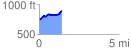
 1.403363 mi
 211.38 ft
 65.51 ft
 145.87 ft
 2.85 %
GPX Downloads: Track Route
![]()
|
| at: |
Talladega National Forest |
show on map
animate
1.403363 mi
211.38 ft
65.51 ft
145.87 ft
2.85 %