|
| at: |
Talladega National Forest |
Data from USFS GIS
 show on map
 animate
Trail users:


Elevation Profile
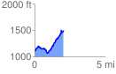
 2.057962 mi
 605.85 ft
 203.97 ft
 401.88 ft
 5.58 %
GPX Downloads: Track Route
![]()
|
| at: |
Talladega National Forest |
show on map
animate
2.057962 mi
605.85 ft
203.97 ft
401.88 ft
5.58 %