|
| at: |
Talladega National Forest |
Data from USFS GIS
 show on map
 animate
Trail users:


Elevation Profile
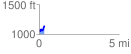
 0.349940 mi
 127.35 ft
 42.94 ft
 84.40 ft
 6.89 %
GPX Downloads: Track Route
![]()
|
| at: |
Talladega National Forest |
show on map
animate
0.349940 mi
127.35 ft
42.94 ft
84.40 ft
6.89 %