|
| at: |
Talladega National Forest |
Data from USFS GIS
 show on map
 animate
Trail users:


Elevation Profile
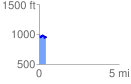
 0.448911 mi
 81.56 ft
 125.13 ft
 -43.56 ft
 5.28 %
GPX Downloads: Track Route
![]()
|
| at: |
Talladega National Forest |
show on map
animate
0.448911 mi
81.56 ft
125.13 ft
-43.56 ft
5.28 %