|
| at: |
Talladega National Forest |
Data from USFS GIS
 show on map
 animate
Trail users:


Elevation Profile
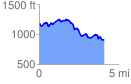
 4.106025 mi
 473.84 ft
 732.02 ft
 -258.17 ft
 3.38 %
GPX Downloads: Track Route
![]()
|
| at: |
Talladega National Forest |
show on map
animate
4.106025 mi
473.84 ft
732.02 ft
-258.17 ft
3.38 %