| at: |
Conecuh National Forest |
Data from David Muse
 show on map
 animate
Trail users:


Elevation Profile
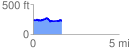
 1.735853 mi
 274.46 ft
 277.81 ft
 -3.35 ft
 3.03 %
GPX Downloads: Track Route
![]()
| at: |
Conecuh National Forest |
show on map
animate
1.735853 mi
274.46 ft
277.81 ft
-3.35 ft
3.03 %