| at: |
Middle Prong/Shining Rock Wilderness |
Data from David Muse
 show on map
 animate
Trail users:

Elevation Profile
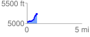
 0.926284 mi
 264.86 ft
 56.89 ft
 207.97 ft
 5.42 %
GPX Downloads: Track Route
![]()
| at: |
Middle Prong/Shining Rock Wilderness |
show on map
animate
0.926284 mi
264.86 ft
56.89 ft
207.97 ft
5.42 %