| at: |
Blue Ridge WMA |
Data from David Muse
 show on map
 animate
Trail users:

Elevation Profile
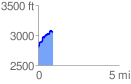
 0.904116 mi
 338.14 ft
 77.06 ft
 261.08 ft
 7.08 %
GPX Downloads: Track Route
![]()
| at: |
Blue Ridge WMA |
show on map
animate
0.904116 mi
338.14 ft
77.06 ft
261.08 ft
7.08 %