| at: |
Lake DArbonne State Park |
Data from David Muse
 show on map
 animate
Trail users:


Elevation Profile
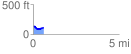
 0.611744 mi
 38.52 ft
 61.98 ft
 -23.46 ft
 1.92 %
GPX Downloads: Track Route
![]()
| at: |
Lake DArbonne State Park |
show on map
animate
0.611744 mi
38.52 ft
61.98 ft
-23.46 ft
1.92 %