| at: |
Old Mill Park Vickery Creek |
Data from David Muse
 show on map
 animate
Trail users:

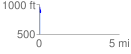
Elevation Profile
 0.098267 mi
 22.08 ft
 89.57 ft
 -67.49 ft
 17.26 %
GPX Downloads: Track Route
Trailheads:
 Old Mill Park
![]()
| at: |
Old Mill Park Vickery Creek |
show on map
animate
0.098267 mi
22.08 ft
89.57 ft
-67.49 ft
17.26 %
Old Mill Park