|
| at: |
Blue Ridge WMA |
Data from David Muse
 show on map
 animate
Trail users:


Elevation Profile
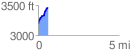
 0.627911 mi
 264.75 ft
 4.26 ft
 260.49 ft
 7.99 %
GPX Downloads: Track Route
![]()
|
| at: |
Blue Ridge WMA |
show on map
animate
0.627911 mi
264.75 ft
4.26 ft
260.49 ft
7.99 %