| at: |
Vickery Creek |
Data from David Muse
 show on map
 animate
Trail users:

Elevation Profile
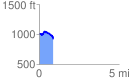
 0.898407 mi
 82.81 ft
 176.29 ft
 -93.47 ft
 3.72 %
GPX Downloads: Track Route
Trailheads:
 Vickery Creek - Riverside Road Lot
![]()
| at: |
Vickery Creek |
show on map
animate
0.898407 mi
82.81 ft
176.29 ft
-93.47 ft
3.72 %
Vickery Creek - Riverside Road Lot