| at: |
Paulding Forest |
Data from David Muse
 show on map
 animate
Trail users:


Elevation Profile
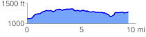
 9.348920 mi
 662.93 ft
 471.72 ft
 191.21 ft
 1.34 %
GPX Downloads: Track Route
![]()
| at: |
Paulding Forest |
show on map
animate
9.348920 mi
662.93 ft
471.72 ft
191.21 ft
1.34 %