|
| at: |
Blue Ridge WMA |
Data from David Muse
 show on map
 animate
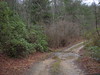
Trail users:


Elevation Profile
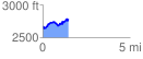
 1.471863 mi
 322.95 ft
 219.63 ft
 103.31 ft
 4.16 %
GPX Downloads: Track Route
![]()
|
| at: |
Blue Ridge WMA |
show on map
animate
1.471863 mi
322.95 ft
219.63 ft
103.31 ft
4.16 %