| at: |
Richloam/Green Swamp WMA |
Data from Karlos Bernart
 show on map
 animate
Trail users:


Elevation Profile
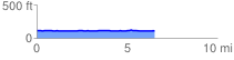
 6.547456 mi
 40.19 ft
 36.85 ft
 3.34 ft
 0.12 %
GPX Downloads: Track Route
![]()
| at: |
Richloam/Green Swamp WMA |
show on map
animate
6.547456 mi
40.19 ft
36.85 ft
3.34 ft
0.12 %