| at: |
Seminole State Forest |
Data from Karlos Bernart
 show on map
 animate
Trail users:


Elevation Profile
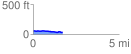
 1.719133 mi
 34.80 ft
 59.50 ft
 -24.70 ft
 0.66 %
GPX Downloads: Track Route
Trailheads:
 Cassia Trailhead
![]()
| at: |
Seminole State Forest |
show on map
animate
1.719133 mi
34.80 ft
59.50 ft
-24.70 ft
0.66 %
Cassia Trailhead