| at: |
Ocala National Forest |
Data from Karlos Bernart
 show on map
 animate
Trail users:


Elevation Profile
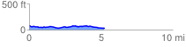
 5.267859 mi
 149.08 ft
 212.70 ft
 -63.62 ft
 0.76 %
GPX Downloads: Track Route
![]()
| at: |
Ocala National Forest |
show on map
animate
5.267859 mi
149.08 ft
212.70 ft
-63.62 ft
0.76 %