|
| at: |
Ocala National Forest |
Data from Karlos Bernart
 show on map
 animate
Trail users:


Elevation Profile
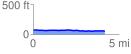
 4.192645 mi
 20.89 ft
 41.27 ft
 -20.37 ft
 0.19 %
GPX Downloads: Track Route
![]()
|
| at: |
Ocala National Forest |
show on map
animate
4.192645 mi
20.89 ft
41.27 ft
-20.37 ft
0.19 %