|
| at: |
Windy Gap |
Data from David Muse
 show on map
 animate
Trail users:


Elevation Profile
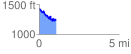
 1.051812 mi
 172.26 ft
 352.54 ft
 -180.28 ft
 6.35 %
GPX Downloads: Track Route
![]()
|
| at: |
Windy Gap |
show on map
animate
1.051812 mi
172.26 ft
352.54 ft
-180.28 ft
6.35 %