| at: |
Chattahoochee WMA/Mark Trail Wilderness |
Data from David Muse
 show on map
 animate
Trail users:

Elevation Profile
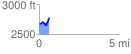
 0.633912 mi
 187.38 ft
 83.85 ft
 103.52 ft
 5.60 %
GPX Downloads: Track Route
![]()
| at: |
Chattahoochee WMA/Mark Trail Wilderness |
show on map
animate
0.633912 mi
187.38 ft
83.85 ft
103.52 ft
5.60 %