| at: |
Fort Yargo |
Data from David Muse
 show on map
 animate
Trail users:


Elevation Profile
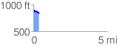
 0.394141 mi
 38.55 ft
 50.03 ft
 -11.48 ft
 2.40 %
GPX Downloads: Track Route
![]()
| at: |
Fort Yargo |
show on map
animate
0.394141 mi
38.55 ft
50.03 ft
-11.48 ft
2.40 %