| at: |
North Oconee National Forest |
Data from David Muse
 show on map
 animate
Trail users:


Elevation Profile
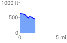
 1.890649 mi
 71.41 ft
 246.38 ft
 -174.98 ft
 2.47 %
GPX Downloads: Track Route
![]()
| at: |
North Oconee National Forest |
show on map
animate
1.890649 mi
71.41 ft
246.38 ft
-174.98 ft
2.47 %