|
| at: |
Windy Gap |
Data from David Muse
 show on map
 animate
Trail users:


Elevation Profile
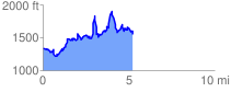
 5.316912 mi
 1996.58 ft
 1782.01 ft
 214.57 ft
 7.11 %
GPX Downloads: Track Route
![]()
|
| at: |
Windy Gap |
show on map
animate
5.316912 mi
1996.58 ft
1782.01 ft
214.57 ft
7.11 %