| at: |
Oak Mountain State Park |
Data from David Muse
 show on map
 animate
Trail users:


Elevation Profile
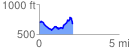
 2.122923 mi
 349.79 ft
 355.61 ft
 -5.83 ft
 3.17 %
GPX Downloads: Track Route
![]()
| at: |
Oak Mountain State Park |
show on map
animate
2.122923 mi
349.79 ft
355.61 ft
-5.83 ft
3.17 %