|
| at: |
Iron Mountain/Sumac Creek |
Data from David Muse
 show on map
 animate
Trail users:


Elevation Profile
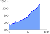
 8.206008 mi
 2198.26 ft
 759.41 ft
 1438.85 ft
 5.07 %
GPX Downloads: Track Route
![]()
|
| at: |
Iron Mountain/Sumac Creek |
show on map
animate
8.206008 mi
2198.26 ft
759.41 ft
1438.85 ft
5.07 %