|
| at: |
Blue Ridge WMA |
Data from David Muse
 show on map
 animate
Trail users:

Elevation Profile
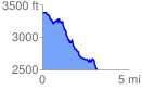
 3.222996 mi
 382.69 ft
 1227.57 ft
 -844.88 ft
 7.21 %
GPX Downloads: Track Route
Trailheads:
 AT - Springer Mountain Parking LotAT - Three Forks