| at: |
Blue Ridge WMA |
Data from David Muse
 show on map
 animate
Trail users:

Elevation Profile
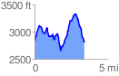
 3.396759 mi
 1224.82 ft
 1255.72 ft
 -30.90 ft
 7.00 %
GPX Downloads: Track Route
![]()
| at: |
Blue Ridge WMA |
show on map
animate
3.396759 mi
1224.82 ft
1255.72 ft
-30.90 ft
7.00 %