| at: |
Johns Mountain WMA |
Data from David Muse
 show on map
 animate

Trail users:

Elevation Profile
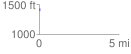
 0.030240 mi
 45.26 ft
 0.06 ft
 45.20 ft
 28.35 %
GPX Downloads: Track Route
![]()
| at: |
Johns Mountain WMA |
show on map
animate
0.030240 mi
45.26 ft
0.06 ft
45.20 ft
28.35 %