| at: |
Blue Ridge WMA |
Data from David Muse
 show on map
 animate


Trail users:

Elevation Profile
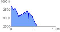
 5.880788 mi
 1218.72 ft
 2385.04 ft
 -1166.33 ft
 7.68 %
GPX Downloads: Track Route
![]()
| at: |
Blue Ridge WMA |
show on map
animate
5.880788 mi
1218.72 ft
2385.04 ft
-1166.33 ft
7.68 %