| at: |
Paulding Forest |
Data from David Muse
 show on map
 animate
Trail users:


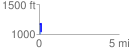
Elevation Profile
 0.148427 mi
 134.11 ft
 128.59 ft
 5.53 ft
 17.11 %
GPX Downloads: Track Route
![]()
| at: |
Paulding Forest |
show on map
animate
0.148427 mi
134.11 ft
128.59 ft
5.53 ft
17.11 %