| at: |
Paulding Forest |
Data from David Muse
 show on map
 animate
Trail users:


Elevation Profile
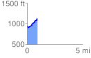
 0.944086 mi
 223.86 ft
 58.53 ft
 165.33 ft
 4.49 %
GPX Downloads: Track Route
![]()
| at: |
Paulding Forest |
show on map
animate
0.944086 mi
223.86 ft
58.53 ft
165.33 ft
4.49 %