| at: |
Paulding Forest |
Data from David Muse
 show on map
 animate
Trail users:


Elevation Profile
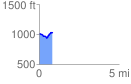
 0.845553 mi
 96.99 ft
 78.72 ft
 18.27 ft
 2.17 %
GPX Downloads: Track Route
![]()
| at: |
Paulding Forest |
show on map
animate
0.845553 mi
96.99 ft
78.72 ft
18.27 ft
2.17 %