| at: |
Paulding Forest |
Data from David Muse
 show on map
 animate
Trail users:


Elevation Profile
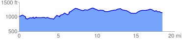
 18.547152 mi
 1309.94 ft
 1228.93 ft
 81.02 ft
 1.34 %
GPX Downloads: Track Route
![]()
| at: |
Paulding Forest |
show on map
animate
18.547152 mi
1309.94 ft
1228.93 ft
81.02 ft
1.34 %