| at: |
Chestatee WMA |
Data from David Muse
 show on map
 animate
Trail users:


Elevation Profile
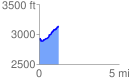
 1.211974 mi
 257.20 ft
 47.82 ft
 209.38 ft
 4.02 %
GPX Downloads: Track Route
![]()
| at: |
Chestatee WMA |
show on map
animate
1.211974 mi
257.20 ft
47.82 ft
209.38 ft
4.02 %