| at: |
Paulding Forest |
Data from David Muse
 show on map
 animate
Trail users:

Elevation Profile
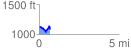
 0.691732 mi
 111.61 ft
 160.80 ft
 -49.19 ft
 4.40 %
GPX Downloads: Track Route
![]()
| at: |
Paulding Forest |
show on map
animate
0.691732 mi
111.61 ft
160.80 ft
-49.19 ft
4.40 %