| at: |
Paulding Forest |
Data from David Muse
 show on map
 animate
Trail users:

Elevation Profile
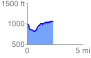
 2.326755 mi
 366.69 ft
 290.47 ft
 76.22 ft
 2.98 %
GPX Downloads: Track Route
![]()
| at: |
Paulding Forest |
show on map
animate
2.326755 mi
366.69 ft
290.47 ft
76.22 ft
2.98 %