| at: |
Paulding Forest |
Data from David Muse
 show on map
 animate
Trail users:

Elevation Profile
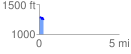
 0.296912 mi
 32.51 ft
 77.06 ft
 -44.55 ft
 4.92 %
GPX Downloads: Track Route
![]()
| at: |
Paulding Forest |
show on map
animate
0.296912 mi
32.51 ft
77.06 ft
-44.55 ft
4.92 %